|
|||||
|
1. Introduction GIS as a recognized information system type has been around since the 1960s and the academic community has been training graduate students in the creation and application of GIS since the early 1970s (beginning at SUNY-Buffalo under Prof. Duane Marble). GIS education normally begins with the definition of what a GIS is: its necessary and sufficient parts, what it is capable of calculating, and the problems it can solve. This definition has evolved over time as has the technology, and here we suggest it is time for another rather radical step forward. No widely accepted one-sentence definition of GIS exists, and as practitioners gain experience with geographic software they often become discontent with even the wider definitions they acquired having read a GIS textbook. [By definition we refer to this wider view, as the idea a person has of GIS after having read a typical GIS textbook or attended a university GIS course.] There may, in fact, be a deeper logical, and philosophical question: do geographic information systems exist outside or independent of the context of information systems in general. This alternative view would see geographic and geographically enabled applications existing in the context of information systems where all data is stored. In this view, geographic information has been subsumed by the generic information system technology. What have in the past been the key elements of geoprocessing have moved to the application level, which now work in "enterprise-wide" information systems. The average GIS definition conveys some of the nature of geospatial data, and describes system architecture of a decade or more ago, but does not really do justice to the GIS students will encounter when they reach the 'real world'. Many of the key algorithms and data structures in the field had matured by the mid 1980s and this, alongside falling workstation prices, allowed for the eventual spread of general-purpose commercial GIS software. Although many features differentiated the various GIS products their underlying architecture was essentially the same: cartographic (or geometry) engines connected to relational Data Base Management Systems. It is therefore not surprising how nearly all definitions of GIS published during the past decade describe this architecture and its capabilities. The field has gone through at least two phases: from the Map Analysis Package phase to the Arc/Info phase to the...where to go now? In this paper we offer a suggestion and an alternative point of view. The de facto standard definition of GIS comes from reading the NCGIA Core Curriculum in GIS (NCGIA, 1990). The utilization over the past 11 years of these course materials in countless GIS courses around the world has essentially created the mould from which many of today's GIS technicians were formed, and it is still the most comprehensive discussion of geoprocessing applications. We do not criticize the Core Curriculum for anything else than being trapped in another time in some of its viewpoints. We also recognize the effort expended to update the curriculum. The spin-off of specialized versions, including the curriculum for Technical Programs, has refined the message for niche audience, however the basic architecture remains unchanged. 1.1 Changes since 1990 Changes since 1990 in the GIS field, like in all technology-related fields, have been truly revolutionary. Just a few examples, in no particular order, are:
From a technology point of view, and considering the 9 revolutions, today's GIS professor is really poorly served by the Core Curriculum (or even it's recent Technical Program update) as they now need to know something about subjects like object oriented design and programming (UML, C++, Java), client-server architectures, metadata, interface specifications, componentware and web and service based programming (HTML, XML). Even at the conceptual level some of the models and internal representations have changed to adapt themselves to this new technology. 1.2 How GIS is taught GIS courses normally consist of a roughly even mix of theory and practical exercises using off-the-shelf GIS products. Until just recently these two methods corresponded rather well, the GIS software allowing students to get their hands on and test implementations of what they had learned in lectures. Increasing, however, the GIS instructor is caught in an interesting dilemma: the well-read academic knows that much of the theory is migrating from map overlay models toward object modeling (such as in the OpenGIS Abstract Specifications and similar models such as those being created by ISO Technical Committee 211), and that these models are then instantiated as object-oriented componentware (often according to OGC Implementation Specs; these specifications are explained further in the following section.) Because these latter specs are so new, and almost no such componentware is commercially available, the conscientious instructor is caught lecturing on the modern approach and then conducting practical sessions using software developed under the previous paradigm (the first author has utilized MapObjects, which do not exactly correspond with OGC concepts, but do use many of the new paradigms). An alternative approach is to continue lecturing the older material and to then introduce the new paradigms in a "future of GIS" lecture near the end of the course; this will be satisfactory for beginning students but not for graduate students (or even Computer Science undergrads) hoping to become GIS builders or users of geomatics technology in applications not classically thought of as "GIS". The academic GIS field is now at a cusp, a decision point similar to (but more profound than) the moment a few years back when the choice was to jump (or not) from Unix to Windows. This is a moment for shifting from vendor-specific definitions and technologies, to those based on industry-consensus; a moment when the eclectic "ivory tower" mode of classical GIS is giving way to the effort to supply generic services to a broad range of geographic and non-geographic applications. 2. Roots of a modern definition Implementations of the previous generation of GIS have never mapped precisely to the theoretical definitions or framework offered in GIS textbooks, however they did share many of the underlying ideas, such as the aforementioned map engines attached to RDBMS, monolithic architecture, etc. The same inexact mapping will be true of the next generation GIS. What will change is the theoretical framework emerging to guide this next generation GIS, based upon the general concepts that were first documented by the OpenGIS Abstract Specification (OGC, 1999). The OGC Abstract Specification essentially defines the relevant terms and data models to be used in distributed GIS software development. As an example take Topic 1: Feature Geometry (which is identical to ISO 19107, a cooperative effort of OGC, ISO TC 211, and ISO/IEC JTC 1 SC 32) which clearly defines the information content of spatial (geometric and topological) objects, how they can be related to each other, and the major operations that can be used to create, modify and analyze them. Another is Topic 6: the OGC Coverage, a subtype of OGC Feature which describes images, TINs, grids and other such structures. These definitions are not absolute truths, however they are industry-wide views of what are the atomic components of GIS, and thus are less vendor-centric and limited than current definitions. The OpenGIS specifications have been developed by many of the top GIS companies and organizations around the world, and anyone present at the OGC Technical Committee meetings will plainly see how they are being adopted in the GIS software of today or the near future. It seems only sensible that students should begin learning about what is being promoted within the industry as the definition of GIS for the next decade. A convenient definition of GIS, as good as many others, would therefore be:
This is the "science is what scientists do" style of definition. While true, it is a bit restrictive in the sense that there are things that the OGC may not cover but are still part of the GIS. It also confuses what might legitimately be considered as mainstream information system technology, which is often reused in the OGC Specifications, used for geographic information with geographic information specific technology. To avoid this confusion we can try to define a geographic component:
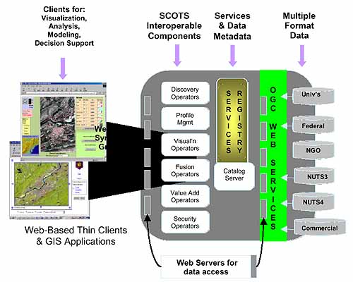
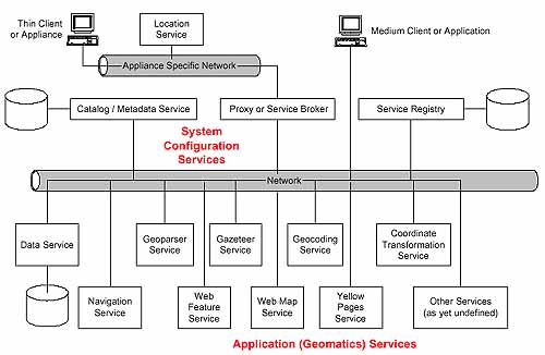
Functionality of a next generation GIS implemented on this form of distributed geoprocessing can be viewed in several manners, two of which are shown in figures 1 and 2. The first is an OGC notional representation of the various services and data sources available to client applications. The second is the authors' reinterpretation, illustrating many of the actual services whose specifications will be published by OGC during the coming 12 months. The OGC Abstract Specifications, describing the low-level meaning of fundamental structures and services and their context, are in the process of being regrouped and rewritten, in part to coincide with the specifications being adopted by the ISO Technical Committee 211 ("Geographic Information and Geomatics"). One of the main benefits of this rewriting exercise, aside from the main benefit of guiding OGC implementation, will be to facilitate the compilation of a sort of next generation GIS textbook from the specifications. 2.1 Alternate Views To understand the vision presented in Figure 1, one must understand the concepts of message / response programming. Derived from a form of object orientation, each operator is seen as an independent entity that can be supported by a service independent of the type of that service. A variant of this view first appeared in Microsoft's COM (common object model) where objects implement interfaces which are sets of related and usually logically dependent operations. Most implementations of this "operator at a time" depend on some variant of a web mark-up language, either a local variant of HTML or, more recently, XML-encoded messages. In this vision, catalogs contain metadata on both data (content, schema, quality, etc.) and services (supported operations, costs, etc.). From a clean start, the client would have to find a service that supports the required operation before invoking it. Theoretically, even if they are to operate on the same data, the client might use different services for each operation required. This system view requires that all data be universally accessible through common services defined on common real-time data transfer formats, and that the semantic control on the meaning of the operations be fairly complete.
The alternative view presented in Figure 2 is consistent with the previous view, but the emphasis is a more object oriented one based on potential use cases. For the extremely lightweight client (one with either limited communication bandwidth, or processing power) a broker or service proxy could be used to eliminate the need for round-trip service hunting. This sort of system view would be very useful for mobile devices such as cell phones, or PDA, whose connection to the network is controlled by a device-dedicated network provider. A medium weight client could handle this on its own. In either case, a separate service registry and data catalog could be accessed so that the client could exercise different levels of control over which service works on which data, including service chaining depending upon the flexibility of the interfaces defined. Figure 2 better represents the topology of the software relations that would be needed to represent programmable use cases. It should be noted that there is nothing special about geoprocessing in either of these diagrams. In fact, as web processing standards mature, the use of geomatics-specific software design frameworks will become unacceptable. This brings us back full circle to the first question: Will geographic information systems be subsumed by information technology in general?
References Buehler, K. and L. McKee (eds.), 1998. The OpenGIS Guide. Introduction to Interoperable Geoprocessing and the OpenGIS Specification, OpenGIS Consortium. Herring, J., 1999. The OpenGIS Data Model, Photogrammetric Engineering and Remote Sensing 65(5), pp 585-588. Levinsohn, A., 2000. Geospatial Interoperability: The holy grail of GIS. GeoWorld, October 2000. http://www.geoplace.com/gw/2000/1000/1000data.asp NCGIA, 1990. NCGIA Core Curriculum in GIS. University of California, Santa Barbara. Out of print but available on-line at: http://www.geog.ubc.ca/courses/klink/gis.notes/ncgia/toc.html OpenGIS, 1999. OpenGIS Abstract Specification, Topic 0: Abstract Specification Overview, document 99-10r1.doc, OpenGIS Consortium. http://www.opengis.org/techno/specs.htm OpenGIS, 1999. OpenGIS Abstract Specification, Topic 1: Feature Geometry, document 99-101.doc, OpenGIS Consortium. OpenGIS, 1999. OpenGIS Abstract Specification, Topic 6: The coverage type and its subtypes, document 99-106.doc, OpenGIS Consortium. Este artículo Copyright 2001, Michael Gould and John R. Herring. |
|||||